The Brian Coburn Boulevard Extension / Cumberland Transitway, is a significant project for the East End, and one that has been in the works for decades.
The City of Ottawa has been able to make some significant progress on this project over the past few years, following multiple public consultations and the completion of technical and environmental design work. The City approached the project considering multiple design options over the years, and following multiple studies and technical / environmental assessments, the list was narrowed to four options. These options were then rated relative to each other, as well as compared to a “perfect score”. From that work, Option 7 was then selected by staff and engineers as the City’s official Technically Preferred Plan.
Many residents have questions about the specifics of this process, what the design options actually look like, and what criteria was considered by the engineers. As this project is two decades in the making, there is a lot of background to the project. On this page, you can find maps and diagrams of the area impacted, as well as the design of Option 1 and Option 7.
You can also find details of the criteria used, as well as how each of the 4 design options rated.
For anyone who may have further questions about any particular aspects of the project, you can reach out to Angela Taylor, PEng., who is the project lead on this file at angela.taylor@ottawa.ca.
The shortlisted options were measured against 31 metrics, sorted into the below overall categories:

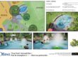
The natural features included in the study area, highlighting areas of natural and scientific interest, as well as a map of the Mer Bleue Bog area:

Below outlines the specific criteria City staff and engineers considered when considering the shortlisted options.

Below outlines the specific criteria City staff and engineers considered when considering the shortlisted options:

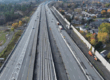
Map of Option 1, detailing the routes for the roadway and the Bus Rapid Transitway. Note: the plans would also include a multi-use pathway.

Map of Option 7, detailing the routes for the roadway and the Bus Rapid Transitway. Note: the plans would also include a multi-use pathway.

The full staff presentation of the Environmental Assessment study.

The complete technical evaluation and scoring of the four shortlisted final options, including their relative performance.